
Day one.
We woke up early on the morning of June 18th, anxious to be on our way. We had been staying in a small Airbnb in downtown Fairbanks for the past two days, stocking up, packing, re-packing and then packing again. Months of online research, phone calls, and long nights scouring through books and maps had finally culminated in an Alaskan wilderness trip that would begin today!

Getting to Gaedeke Lake requires two flights from Fairbanks, with a stop in Bettles on the way. Bettles is the last stop in civilisation before you go into total wilderness. This is where you can check in with the National Park Service, rent bear canisters and buy some last-minute goods.
The flight from Fairbanks to Bettles was by far the coolest plane ride we’d ever been on. The Alaskan landscape was beautiful, full of green and covered in water; an unbelievable amount of water. The flight follows the Trans-Alaskan pipeline and the Dalton Highway north, which is a pretty epic thing to witness in itself. The pilot pointed out the Yukon River, before announcing our entry into the Arctic Circle. We were well and truly in the North now.
Once in Bettles, John and I met up with Judy and Jay, who run Brooks Range Aviation, and they introduced us to our legend of a pilot, Tom. We loaded our gear into a small Cessna 185 floatplane and we were airborne once more.
The flight was amazing, but as we rounded the last bend we saw a very, very, very unwelcome sight: Gaedeke Lake was iced over! The Brooks were experiencing a late summer, and we were still early in the season. This could be a problem.
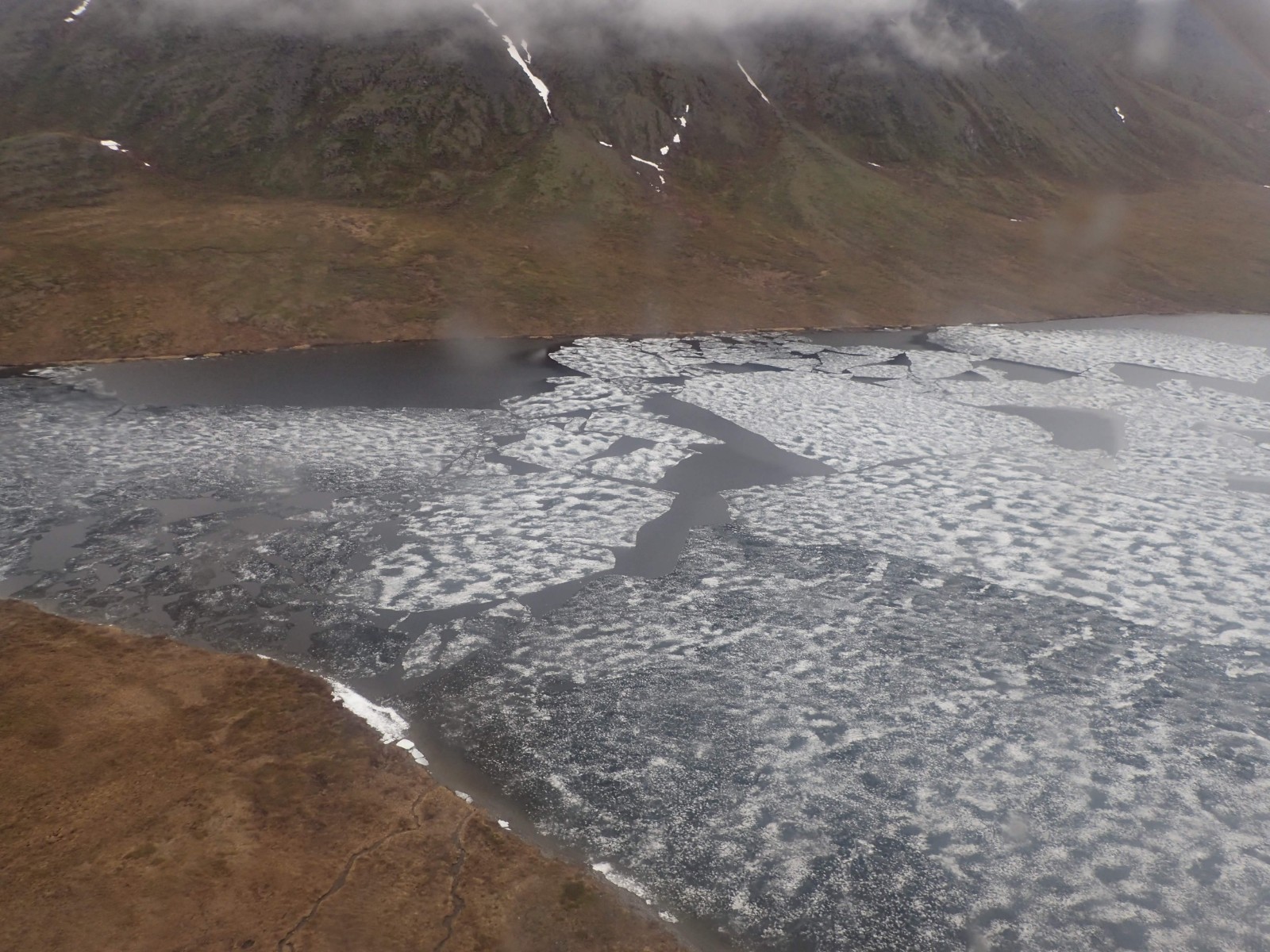
We rerouted, landing 2-3 miles further north on a different lake, putting us a few hours away from our first night’s camp.
After Tom had unloaded us, he was off, leaving John and I in total silence. Seeing that plane take off was such an unreal experience. 11 days in the arctic tundra and not another human soul for miles and miles.

The slog back to Gaedeke Lake was the toughest hike of my life (this is a phrase you’ll read a few times over the course of this blog). The Alaskan tussocks are real ankle-busters, and any ideas you may have had about keeping your feet dry are immediately thrown out the window. We carried all 140 pounds of our gear for three miles and by the time we got to the lake, we were completely stuffed.
We stopped by John Gaedeke’s cabin on the way through and saw our first signs of bears. There were claw marks all over the cabin and chunks of wood had been torn off the walls. Needless to say, we kept the bear spray very close at hand.

We set up a quick camp, did a final scan for bears and then hit the hay.
Day two.
After 12 hours sleep, we emerged from our tents and got a fire going to dry our boots. John’s boots caught fire for a brief moment, but we managed to save them before they were too damaged.
By 9am, we were blowing our rafts up and tying our gear down. The rafts inflate with a handy pump sack, so it was quick work. We used two dry bags each. I had a large 70L that I stashed most of my gear in, including my backpack, and then a smaller 25L one for boots and food. The bear cans aren’t watertight, so we had to keep them in dry bags as well.

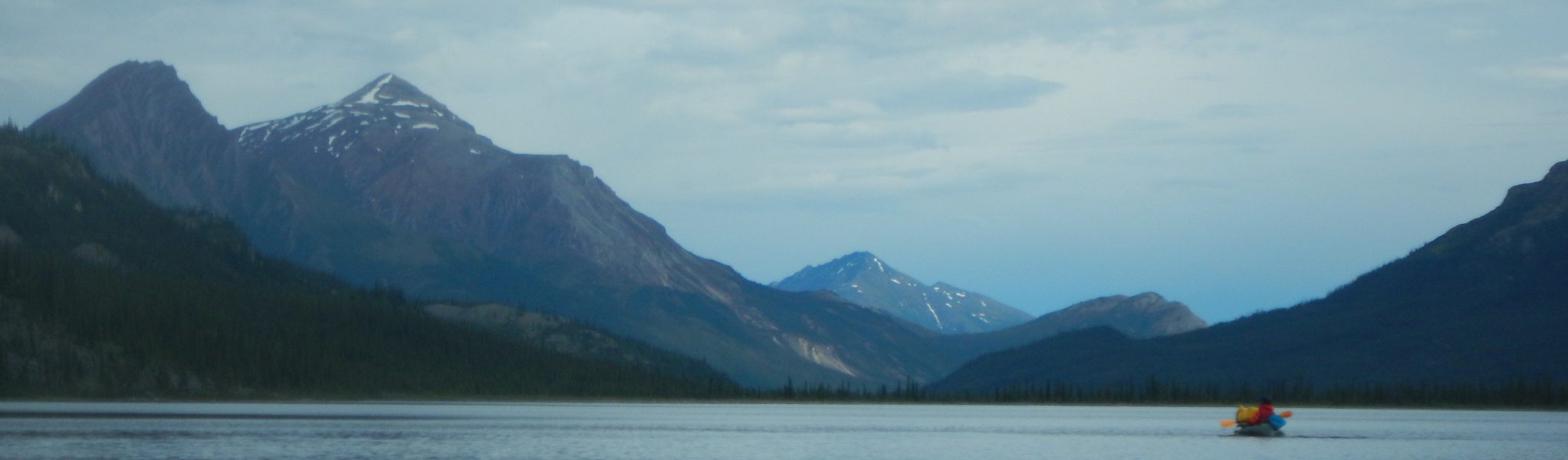
The lake was freezing cold, but getting out onto the water was exciting. We paddled across the lake, but only made it down the river a little way before I was caught in some overhanging brush and nearly tipped. It was an ominous start.

After that, we used the rope to walk our rafts down the river. We were able to paddle through some sections, but for the most part, the river was too fast and too shallow.

Once we had each flipped our rafts twice, we decided to call it a day. The river was not like in the postcards. It was finally dawning on us that this might not be as easy as we had thought.

John spotted a sweet little hill and we set up camp about four miles from where we had started. No hope of a fire, as we couldn’t get any of the wood to take off, but we still treated ourselves to steak and potatoes for dinner.

Even with the eternal Alaskan sunshine, we found ourselves passing out by 9pm again. Navigating the icy river was tiring work.
Day three.
The morning started with a hike, then John and I planned our day over a hot chocolate on a nearby ridge. We could see the Weyahok River joining the Alatna up ahead, and we figured that once the two rivers joined, we’d be able to start paddling again. So far the Alatna had been fast and tough to manage.

We roped our gear to our rafts once again and we were off. After an hour of lining, we hit the Weyahok confluence and our assumptions had been correct – we could finally start rafting!
There were plenty of hairy spots and some pretty big bumps from the rocks below, but nothing that we couldn’t handle. The amount of ice that was sitting along the river was insane. There was ice melt literally gushing off of the aufeis sheets and every now and again a large slab would break away and crash into the water. The first time this happened, I thought that a bear had dived into the river behind me – I paddled away as fast as my arms could take me.

Disaster almost struck when we turned one corner to find the whole river covered in ice, bank to bank. The river continued to flow straight under the wall of ice and was threatening to drag us under as well. With a titanic effort, we managed to pull our rafts back up the river and get out of the water, but it was a close call.
Lesson one: ice on river = dangerous.
John and I decided to camp at the next spot we could find. After another bend in the river, we saw a decent gravel bar, but when we pulled up to talk about it, we got turned about and John’s raft flipped. He came out of his raft and our one loose bag of items took off down the river.
Within seconds, the contents of the bag were spilling out. Bowls, pots, rafts, pumps, toilet paper, fire-starters, etc all making their own personal dashes for freedom. We ran after them a few hundred feet, but it was a wasted effort, the river was too fast and rough.
With heads hung low, we pulled up on the gravel bar and got changed into our dry kit. There was plenty of good wood around so we went to work collecting it right away. While we were looking around we found some wolf tracks – a mum and her cub. It was worrying, but we were way too tired and cold to move on. Bring on the wolves.

Luckily they never came. Instead, we got our fire going and then went for a short walk up the valley to chill and chat. This place was beautiful, but the conditions were so harsh. The trip was turning out to be more than we had bargained for, but we were still confident that we could handle anything that came our way. Cheers to another beautiful day in Alaska!

Lesson two: tie everything down, or the river will take it.
Day four.
Everything dried out overnight and we took our time getting packed up and roped away. As we gathered our belongings, a light rain set in, and did not let up for the rest of the day. It never bucketed down while we were in the Brooks, but the drizzle was pretty constant.
We lined our rafts through an initial rough patch, and then we were off to the races – this would be our best day of paddling yet. The river was much more manageable but also much wider and more dynamic. We had some open river, some class II/class III rapids, and then some hairpin turns that were downright scary. The margin for error on some of these sections was 10 feet, or you would get sucked under boulders.

Despite the challenges, there were plenty of opportunities to soak in the beauty around us. We passed waterfalls and mountains, creek inlets and rock pools. It was stunning. Everywhere green and everywhere water. John even managed to find his water bottle that had floated away the previous day!

We had been cruising for about 3 hours and I was getting cold and wanted to find a spot to camp. John, however, wanted to keep going through the Ram Creek rapids, what we anticipated to be the most difficult section of the river on our trip. We decided to take a swing at it and everything was going well until a large swell from the side flipped my raft!
The world turned upside down as I came out of my raft, and a loose length of rope grabbed my leg, pulling me sideways. I was panicking. The water was rough and I was struggling to keep my head above water. I grabbed my raft and paddle, and kicked for a nearby gravel bar with my one free leg.
A bear can of food took off down the river, but John had stopped ahead and was able to snag it. I kicked towards him, and he helped to pull me and my raft out of the water. Time to reassess our plan.
It was still raining and now we were both drenched and cold. We decided to pull up at the next spot we could find, a low bank around the next bend. Having set up camp and changed, we had a drink to chill out. Everything was soaked. We went to bed in good health, but also a little miserable.
Lesson three: loose rope in your raft = stoopid.
Day four continued.
Two hours after going to bed, I woke to find that my tent was almost in the river. The water level had risen, and the Alatna was torrenting down the valley. Our food was close to being swept away and John’s raft was in the water, clinging to a small tree for dear life. And the rain was still coming down.
We leapt into action, rushing to drag our tents and food to higher ground. The rising water had created a creek behind us too, leaving us stuck on an island. Exhausted and wet, we went back to bed, just a little more miserable.
Lesson four: camp up high.

Day five.
The river continued to rise overnight, but thankfully the rain had subsided. We pulled the food higher and hung our wet gear out to dry in the sun. Hopefully, there would be at least one dry thing to wear by the end of the day.

The Alatna was relentless. 50-foot pine trees cruised past us down the river at high speed as we sat and watched. The water had turned a chocolate brown colour and there were three-foot-high swells. We hoped that with the rain gone, it would just be a case of sitting and waiting for the river to drop back down. We caught up on a lot of sleep that day.

Having marked the high water point with a rock, it looked like the water had stopped rising at last. Our gear was starting to dry and the sun was shining. Things were looking up! With an improved outlook on life, we decided to dig into some more food. Sleeping is hungry work!

The water was too dirty to drink so John crossed over to Ram Creek, behind us, and snagged some clean water. We got a small fire going and made a saucepan out of aluminium foil in an attempt to make a coffee. Two days of cold food had left us desperate for something warm. Despite being one of the worst-tasting coffees I’ve ever had, it was also one of the most enjoyable.
The rain began to kick back in by 5pm, so we called it a day. According to our rocks, the river had dropped a foot and a half. Tomorrow we were setting sail. Arrigetch Creek was 19 miles away and once we got past the first six hairy miles, it would all be smooth sailing (we hoped). Here’s praying for clear skies.
Day six.
We woke up to blue skies and low water. This was it!
We whacked some peanut butter on tortillas and got our rafts ready to roll. The water was still a murky brown, but the crazy flows of the day before were gone. Thankfully, there weren’t any trees floating down the river.
After saying a few prayers, we took off. Everything was going smoothly and I was just getting my rhythm back when an eddy from a large rock flipped me over. Again. Bugger.
After that, the occasional eddy kept things interesting but mostly this was a very relaxing day of paddling. More like what we had expected from mile zero. John ended up flipping his raft too and although we were able to retrieve his oar, one of his shoes was lost to the river forever. RIP shoe. It took us around six hours to reach Arrigetch Creek.
We pulled up on the south side of Arrigetch Creek, in search of the social trail, a well-used game trail we had read about, that makes it much easier to climb to the Arrigetch Peaks. We tied our rafts into some trees and left all the food we didn’t want to carry.
Once our packs were ready, we were on our way and got a full minute into our hike before we hit another creek. Bugger, we were on the wrong side!
Luckily, this was just a small braid of Arrigetch Creek. It was too wide to jump, but with a little ingenuity, we managed to ford across. We untied John’s raft, stripped down and loaded it up with all of our gear. We slowly brought it all over in the freezing cold water and then re-geared up. Now, we were on our way.
Half an hour of walking through the thick scrub was rewarded when we finally found the actual social trail, and it had some fresh human tracks!

The next four hours were a blur as we trudged through the toughest hike that I had ever experienced in my life. I’m a fit young bloke, but this trail really took the wind out of me!
There were plenty of cuss-words, branches to the face, and sopping wet boots before we finally found the group responsible for the tracks we’d seen earlier. It was a little German family! A father, son, and daughter in law. We said g’day and exchanged some small talk.

These guys had been dropped at Circle Lake and were spending a few days hiking around the peaks, before taking to the Alatna and paddling to Allakaket. There, they would meet up with the mother and spend another week or two ‘glamping’ around Alaska in an RV. This family was the real deal.
They also told us that there had been a grizzly spotted up the valley within the last couple of days – a mama bear and two cubs.
After a bit of chit-chat, John and I decided to capitalise on the moment, and we asked to borrow a pot since the river had swallowed ours. It had been three days since our last hot meal. Our new German friends actually gifted us one of theirs, for which we thanked them profusely.
We moved on and hiked another hour or two, before we landed upon a perfect little camp spot just as it started to rain. We set up in a hurry, had some ramen (hot food!) and then settled in to sleep at 1am.
Day seven.
Day seven began at 9am, with some light showers and the chance to make use of our shiny, new pot again. Coffee and oats for breakfast! As we packed up, it started raining, and my tent was instantly soaked along with my clothes. Only once everything had been stashed away did the rain subside. Mother Nature is a cruel mistress.
Another serving of oats and we were almost ready to go. The German family passed us on the trail and before long we set off behind them.
The trail was hard and full of boulder crossings. You could literally hear creeks flowing beneath the rocks. It was hard to grasp how much water was gushing through this valley.

The creek was raging in the valley below us as the Arrigetch Peaks slowly drew closer over the course of the day.

We crossed a few streams before finally reaching a creek that was too big to hop across. Again, we stripped down, and this time we tried to throw some of our belongings over to the other side so they wouldn’t get wet. It didn’t work. All of it landed in the water, but luckily, nothing was whisked away. We geared up on the other side and continued along the trail. Wet.
Lesson five: don’t throw important possessions over fast-moving, turbulent water. Also = stoopid.

We crossed paths with the German family once more on our way through to the peaks. They had set up camp down low and were planning to make smaller day trips up into the mountains. This seemed like a good approach but John and I had a date with the base of these mountains. We passed on through.
One last creek crossing went awry as John lost his footing and fell into the water with his bag on. I spent a little extra time making my way over and managed to stay dry from the knees up (that counts as a win).
In our new camp, we laid all our gear out to dry and then soaked up the sun for the rest of the day. It was a perfect end to the toughest hike of my life.

We had paddled, flown and hiked so many miles to reach this place. What a great feeling! We went to bed with high spirits, looking forward to the hikes ahead of us in the coming days.
Day eight.
It was much colder this morning than the day before. We got up around 8am to see that the blue skies of yesterday had all but disappeared and low flying clouds were rolling in. As we were getting zipped up in our warm gear, a light rain started.

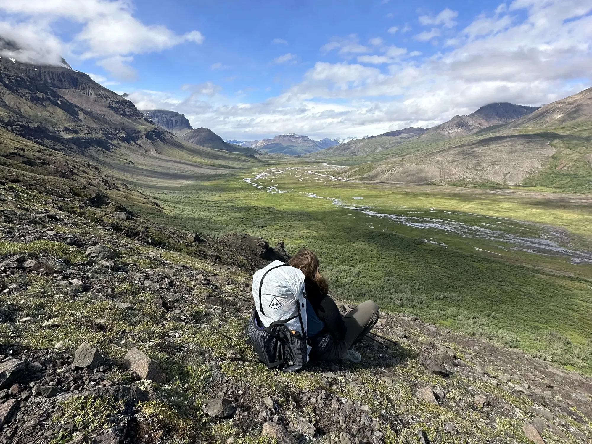
We started hiking up towards the peaks closest to us, climbing over boulders and crossing streams to reach the upper valley floor. Every time you crested one ridge there was another hidden behind it. Huffing and puffing, our struggle to the top was rewarded with a spectacular view of the peaks.
The name Arrigetch translates to ‘fingers of the outstretched hand’, and from where we stood, we could see why. Sharp, jagged mountains reached up like giant fingers around us as we stood in the palm. We took a few glam shots and enjoyed the view over some trail mix, before moving on to Aquarius Valley.

Finding the social trail again involved carefully navigating our way around the mountain. We crossed a creek beneath a small waterfall and pushed on through more fields of boulders. Plenty of breaks and sharing the backpack helped us make our way along.
When we finally reached Aquarius Valley, the view that greeted us was breath-taking.
Ice floated on the most beautiful, crystal-clear lakes that I had ever seen. Walls of black rock surrounded the water and reached hundreds of feet into the sky in every direction. The sheer size of the place was very humbling.

We found a spot for lunch and enjoyed our sachet salmon and tortillas in total silence. A small bird hopped along the floating ice, investigating the two strange visitors to its lake.

We made good time heading back down the mountain, and the weather cleared up as we went.
Hot chocolate for dessert and then off to bed. Tomorrow we would be heading back down to the Alatna.
Day nine.
I woke up around 6am to the sound of heavy rain. Bother.
We sat through a massive coffee and oats sesh, chatting and saying our goodbyes to this magical place. This might be the last time we ever set eyes on these mountains in person.
The valley was looking grim as we set off, and we had six miles to cover before we hit the German’s first campsite – our target for the day. The hike down was much easier than the hike up, aided by the favourable slope, and our slightly worrying lack of food weight.

The social trail was paying dividends and all was uneventful until we stumbled upon a gigantic bear print on the trail. Fresh in the mud and headed down the valley, John and I sobered up immediately. We took turns shouting “hey bear” at 5-second intervals and slowly chipped away at the remainder of our hike. 1 mile to go. 0.9 miles to go. 0.8 miles to go. The mood was tense.
The tracks continued to follow the trail and appeared to be getting fresher. We decided to shoot straight up the valley wall and hope to hit another game trail. Our aim being to get off of this bear’s tail and have a better view of what was in front of us. We eventually made it to the campsite in one piece, and once we did, the view was spectacular.

A fleeting sun, a warm fire, and some sub-par ramen made for a great evening and we retired to our tents as the sun disappeared behind some mountains.
We needed sleep. Tomorrow, we would tackle our last day of paddling to reach our pickup at Takahula Lake.
Day ten.
8am saw us hit our usual routine: fire, water, poop and coffee – in no specific order. The sky was clear blue and the sun was warm. We devoured a huge bowl of oats next to our fire as we sat and stared at the distant peaks for the final time. We were still wary of bears from the day before, so we made our presence known as we went along the social trail.
We easily located John’s raft using our GPS, and the rest of our river gear soon after. Nothing had been touched! As we prepared for launch, we heard the thunderous roar of a storm rolling in. As usual, Alaskan weather was threatening to ruin a perfectly good day.

We hurriedly packed and got back on the Alatna. The river was running slow and casual, a welcome relief from all the tough hiking over the past few days. With the storm creeping closer however, the thunder was getting louder and more frequent.

Before I knew it, I was waist deep in water, with rain splashing off my cap and thunder overhead. Our first thought was to stop and set up camp, but we didn’t want to risk getting stuck in another island situation. We pushed on. The thunder raged right over the top of us, across the valley, and eventually subsided.
We paddled past our German compadres, who had decided to camp through the storm. Waves were exchanged, and we paddled on through the rain.
Eventually, the rain lifted and we were back to casual paddling. The mountains became more rugged and interesting as we moved further down the river. Straight pines and little waterfalls littered the landscape.

We saw our take-out approaching and pulled to the side of the river. As we jumped out of our rafts, we landed in shin-deep mud. Bother again. Nothing can ever be easy out here. We dragged and cursed our way through the mud until we hit solid ground. Apparently, a moose had been through the same struggle earlier that day, as our small footsteps crossed it’s much, much larger ones.
One at a time, we hauled our rafts over to Takahula Lake for a final paddle. It was a gruelling 1000 ft hike, but we managed it. Takahula Lake was incredible. Crystal clear water, turning emerald as it deepened. The surface was still, and the mountains reflected perfectly off of it.
Paddling across the lake to reach our pickup spot, we took small breaks to appreciate the surroundings as we went. We passed a beautiful log cabin along the way, encircled by bear wire. “No trespassing” signs were a prominent feature. What a perfect place to have a getaway house!

As we reached the far shore, we spotted a beaver paddling its little heart out. John made a beeline for it and the beaver smacked its tail on the water to create a diversion and dove. It soon popped back up, swimming in the opposite direction. A pretty neat little sight.
I parked next to his dam (sorry mate) and pulled our rafts up. This was our final camp spot! We set up and then bathed for the first time in 11 days. John had brought soap.

On the menu for tonight was Mac n cheese, a backpacking delicacy, followed by a double serving of chicken noodle soup. Hot chocolate for dessert and then we were set for bed.
This entire trip had been such a wild adventure, and we had finally reached the end. We went to bed feeling very fulfilled, but absolutely 100% flogged. Come and get us, plane. We’re ready for a beer!

Day eleven.
I woke in the middle of the night and thought I heard a bear. After I retrieved my bear spray, I realised it was just John snoring. Back to sleep!
We emerged around 8:30am and began packing up our gear and boiling water. It was a gorgeous, sunny day and the lake was calm. Most of our gear had dried overnight.
We made a massive bowl of oats and a hot chocolate which we enjoyed by the lake. Everything was beautiful.

The boats were folded up and our gear was stowed, so there was nothing for it but to play the waiting game.
It wasn’t long before we heard the drone of our plane coming in. We were hollering and waving our arms like madmen. It circled the lake once and then settled in for a landing, and as chance would have it, Tom was the pilot!

Tom was a little surprised to see us in one piece. He told us that he’d gone looking for us after the massive storm that had grounded us at Ram Creek. Two groups on nearby rivers had been airlifted out by rescue services.

The flight out was spectacular and it wasn’t long before we landed back in Bettles. We wolfed down a frozen pizza, bean and cheese burritos and some bananas. It was the most delicious food I’d ever eaten.
Brooks Range aviation offered to put us up in one of their free bunkhouses. However, a student park ranger from CU Boulder, Teddy, let us crash on his couch. Win! We ate teriyaki salmon for dinner at the Bettles Lodge and mingled with the locals over beer and pool. All great people, and all big adventurers.
Sayonara.
The next day, after saying our goodbyes around the little town of Bettles, we were off once again, but this time, back to civilisation.
It was a little saddening, but John and I had both had such an amazing time out in the wilderness that we couldn’t stop smiling. We’d managed a pretty incredible feat and most importantly, we were going home in one piece, safe and sound.


Leave a Reply